Category Archives: Other

Wupatki National Monument (Arizona)

I am planning a first time visit in a couple of weeks, and I think your site is especially good because it gives good, practical advice (like how to get there without having your car swallowed by a mud hole in a never traveled highway). …

I plan on leaving in early May, and am stopping at Tuzigoot, Montezuma Castle and Canyon de Chelly before Chaco, and then going on to El Mapais, El Morro, Petrified Forest, Homolovi, and finally Walnut Canyon before heading home. I am watching the weather closely, trying to avoid rain/snow…. R.

R-

I took a very similar trip to yours a couple of years ago; saw many of the sites you listed. I was stunned by Montezuma’s Castle; see The Well, too, and walk down to the ancient water channel along the stream.

I know how hard it is to see it all, but let me suggest you add Wupatki National Monument, just a little north of Flagstaff, AZ. There is an interesting overlap/collision of features from Anasazi, Hohokam and, maybe, Sinagua. It would add at least a few hours to your trip, but I think you’d like it. It is the most like Chaco in condition and size of ruins. And add Hovenweep National Monument (UT/CO) to your list for future trips.
mjh

Wupatki Ruin -- not my photo
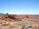
Arizona – Wupatki National Monument

Wupatki National Monument is one of several sites preserving pueblos (houses) of ancient peoples, but unlike the Tonto, Montezuma, Casa Grande and Tuzigoot Monuments where there is only one main building, here there are many ruins scattered over a large area of desert northeast of Flagstaff. The pueblos all have a distinctive red colour and were made from the local Moenkopi sandstone.

Wupatki National Monument (National Park Service)

For its time and place, there was no other pueblo like Wupatki. Less than 800 years ago, it was the tallest, largest, and perhaps the richest and most influential pueblo around. It was home to 85-100 people, and several thousand more lived within a day’s walk. And it was built in one of the lowest, warmest, and driest places on the Colorado Plateau. What compelled people to build here?
Human history here spans at least 10,000 years. But only for a time, in the 1100s, was the landscape this densely populated. The eruption of nearby Sunset Crater Volcano a century earlier probably played a part.

Wupatki National Monument (DesertUSA)

GORP – US National Monuments – Wupatki and Sunset Crater

Mesa Verde National Park in Southwestern Colorado

Mesa Verde — dwellings from the past by Kim McMahill, Carlsbad, N.M.

High above Colorado’s Montezuma and Mancos Valleys rises a large plateau that contains abundant archeological treasures. Mesa Verde National Park, established in 1906, occupies a large part of the plateau and is home to the remains of dwellings constructed 700 years ago by the Ancestral Puebloan people (often referred to as Anasazi).

More than 600 cliff dwellings have been identified by archeologists on the mesa top and in rock alcoves in the canyon walls. Of those, about 40 pueblos and cliff dwellings are visible from park roads and overlooks. Many are open to the public, but some, like Cliff Palace and Balcony House, require tour tickets in order to enter the fragile structures.

From the park entrance it is a 15-mile drive to the Far View Visitor Center. There are limited ruins in this part of the park, but Far View is still a good place to get oriented. Park maps and tour tickets are available at the visitor center along with sweeping vistas of the plateau and access to park rangers for asking questions.

About six miles further up the road is where things begin to get really interesting. Multi-storied dwellings nestled into sandstone cliffs are clearly visible from marked pull-outs. The size and complexity of the structures is simply amazing. Contemplating the need by early residents to have such inaccessible dwellings and their later abandonment of the site make visiting the area an intriguing adventure.

Mesa Verde National Park is located midway between Cortez and Mancos, Colo., off of U.S. 160. Park roads are open from 8 a.m. to sunset. During the winter months roads and tours are open and available as weather permits, so it is advisable to check with the visitor center before venturing out.

For more information, log on to www.nps.gov/meve or call (970) 529-4465

Virgin River Recreation Area, Northwest Arizona

map of Virgin River Canyon Recreation AreaA world away
Virgin River Recreation Area campground is gateway to remote area
By Susan Whitney, Deseret Morning News

This recreation area — 75 campsites (there are picnic sites, too) is open year-round — is a gateway to one of the most remote areas of the United States. This portion of the Virgin River is the border between the Paiute and the Beaver Dam Wilderness Areas.

The Beaver Dam Wilderness Area is 19,600 acres, circumvented by Cedar Pocket Road. The Paiute Wilderness area is 84,700 acres of mountains and desert.

What: Virgin River Recreation Area
Where: 20 miles southwest of St. George. Take exit 18 on I-15.
How much: Campsites are $6 a night; half off for Golden Age or Golden Access holders. Many are pull-through sites.
Reservations: Only taken for three group campsites.
Phone: 435-688-3200

Canyons of the Ancients National Monument, Colorado

Curtis Singmaster, of Vermont, and his mother, Karen Singmaster, of Hesperus, begin a morning hike Wednesday at the south end of Sand Canyon off Road G. Joining the hike is Karen’s dog, Calleyon.Panel’s plan would expand Canyon’s access By Steve Grazier, Cortez Journal

A plan for transportation management at the Canyons of the Ancients National Monument was unanimously approved Tuesday by the monument’s citizens advisory committee. …

The committee’s decisions are recommendations to the Bureau of Land Management, the federal agency charged with management of the monument.

Some goals of the transportation plan include providing protection of resources for present and future users, avoiding detrimental impacts of privately held resources within and adjacent to monument boundaries and designating six to 10 access points. …

Currently there are five main access points at the monument.

The monument was designated by then President Clinton in 2000 because of the high concentration of Ancestral Puebloan ruins on the 164,000 acres northwest of Cortez.

Lake Powell shrinks, reveals Glen Canyon

This is a longish (6-page) article on Glen Canyon and Lake Powell. It has some of the history, the two major perspectives, and some of the personalities involved. McGivney suggests that nature may be undoing what man has done, politics be dammed. mjh

Backpacking Destinations – Paradise Found
Somebody forgot to tell Mother Nature that Glen Canyon was lost forever.
By Annette McGivney, BACKPACKER Southwest Editor, April 1, 2004

The Southwest is now 4 years into a drought that has more than halved Lake Powell, dropping water levels a record 100 feet.

At Northern Arizona University, hydrologists have developed a computer model that predicts that the reservoir’s remaining water will dry up with only 10 years of medium-scale drought. If severe drought continues–like the current dry spell that’s halved the reservoir in just 4 years–the end could come much sooner…. Two out of five marinas are landlocked; in fact, Hite has become a ghost town. Meanwhile, unemployment is rising, and visitation has dropped off by 40 percent. …

The saga of Glen Canyon Dam is long and knotty, but here’s the executive summary. Completed in 1963 on the Utah-Arizona border, the 50-story structure took 10 years, $330 million, and 4.9 million cubic yards of concrete to build. When Lake Powell was full, it contained 8.8 trillion gallons of water; it now holds 4.2 trillion. While a little water is drawn to supply local needs, the dam’s primary purpose has been to generate hydroelectricity. To that end, eight giant generators rumble away deep inside, producing up to 1.32 gigawatts at any given moment, enough juice to power a city of more than 1 million people. A digital sign inside the power station reports the gross earnings to date: just north of $2 billion.

Glen Canyon is one of six dams on the 1,400-mile-long Colorado River drainage, which stretches from Wyoming to where it fizzles out just inside Mexico. Like a conveyor belt, the system transports water from one impound to the next to serve 30 million people. …

As David Brower would lament when it was finished, Glen Canyon Dam was the product of political horse-trading. In the 1950s, the Bureau of Reclamation announced plans to build dams in Dinosaur National Monument and the Grand Canyon. Brower and the Sierra Club fought off the attempt to flood national parks but agreed not to dispute the dam in Glen Canyon, a place too wild and remote to have many champions and a place Brower didn’t visit until it was too late. Soon after the dam gates closed, the Sierra Club published a photo-heavy eulogy for what was lost: The Place No One Knew. …

In 1995, Ingebretsen founded the Glen Canyon Institute with the goal of decommissioning the dam. Today the nonprofit has 1,300 members, an annual budget of $200,000, two full-time staffers–and uncertain hope if the rains return. Ingebretsen is undeterred, aware that Mother Nature is giving his grassroots campaign a powerful boost. “Glen Canyon Dam serves no legitimate purpose,” he insists, as he prepares to launch a screed about species extinction and pork-barrel patronage. “It was built for political reasons, and it remains today for political reasons.” …

“A free-flowing Colorado isn’t worth a god damn to anybody,” insists Floyd Dominy, the former Bureau commissioner who famously wrote that creating Lake Powell seems to bring man “closer to God.” At 94, Dominy is as full of brash, head-scratching hyperbole as ever. “I can’t even find the words to describe the beauties of Lake Powell. I consider Glen Canyon dam my biggest accomplishment in life.” …

We walk toward the mouth of Clear Creek, where water gurgles from algae-covered rocks. Ingebretsen wants to show me that Glen Canyon is not dead, not buried beneath a flood of sediment. “You can see the plant life is already coming back,” he gloats. “The silt quickly flushes out and the algae, ferns, and frogs return.”

Keet Seel and Betatikin Ruins in Navajo National Monument, Arizona

We hiked to Keet Seel many years ago to visit our friend, Ranger Rob, who was posted in the backcountry by the ruins. The ruins were quite impressive, though there are many, many impressive ruins throughout the Four Corners area.

It was quite a hike. I stepped in what I’d call ‘quickmud’ — it looked solid but was almost liquid. In the public campground, Germans camped nearby argued late in the evening until I yelled “Schweigen!” mjh

ABQjournal: Touch the Past in Anasazi Ruin By David G. Jackson, ABQJournal.com

Keet Seel ruin

LOCATION: In the Navajo National Monument, about 40 miles southwest of Kayenta, Ariz. The ruin is 8-1/2 miles north of monument headquarters at the end of a well-marked trail. The Betatakin ruin, located about 2-1/2 miles from monument headquarters, is also available to hikers.

ROUND-TRIP DISTANCE: 17 miles
DIFFICULTY: Moderate
ELEVATION GAIN: 1,200 feet
PRECAUTIONS: The National Park Service recommends two gallons of water be carried for each hiker because there is no drinking water in the area. Summer visits can be very hot. Rain can cause flash flooding, and quicksand often forms around large rocks in the river bed. All hikes to the ruins must be accompanied by a park ranger.

BEST SEASONS: The ruin is open from Memorial Day to Labor Day.

MAPS: A trail map to the ruins is available at monument headquarters. Current USGS 7.5 quad topographic maps do not show the location of ruin.

CAMPING: Navajo National Monument has a good campground with water, but no other services. However, it is not far from a trading post, and visitors can drive to Kayenta for a good evening meal and other supplies.

RESERVATIONS: The park service recommends calling for reservations no more two months in advance. The number of visitors per day is limited to 20, but no fee is required. Likewise, no fee is required to visit Betatakin, but tours are limited to 25 people. The hike departs at 8:15 every morning, and it’s best to sign up the day before. Call: (928) 672-2700.

[Read the article…]
Continue reading Keet Seel and Betatikin Ruins in Navajo National Monument, Arizona

New National Monuments

Newest National Monuments

The American people have 21 spectacular new national monuments to explore and to cherish. Canyons of the Ancients, Grand Canyon-Parashant, Pompeys Pillar — their very names evoke mystery, wonder and adventure. Fifteen of these monuments are part of the National Landscape Conservation System (NLCS) and are destined to become as precious to Americans of the 21st century as our National Parks have been to each of us.

Arizona 5
California 5
Colorado 1
Idaho 2
Montana 2
New Mexico 1
Oregon 1
Utah 1
Virgin Islands 2
Washington DC 1

Most of these areas are part of the under-funded NLCS.

Petrified Forest National Park (Arizona)

Growth nears Petrified Forest
Subdivisions imperil park expansion plan, ranchers say
by Mark Shaffer, Republic Flagstaff Bureau

For nearly a decade, some of the state’s largest ranchers have waited patiently to strike a deal with the federal government to enlarge Petrified Forest National Park and protect the area’s geological and archaeological treasures.

But time appears to be running out as development pressures increase and the ongoing drought makes the cattle industry less viable.

Meanwhile, bills seeking the park’s expansion by 97,000 acres, doubling its size, languish in U.S. House and Senate subcommittees with no hearing dates scheduled. And the state, which has been a latecomer in endorsing the expansion, still faces a laborious process in determining the value of State Land Department property that would be involved in the process.

Holbrook rancher Mike Fitzgerald, owner of the huge Twin Buttes Ranch, which borders the west side of the Petrified Forest, says he’s had enough waiting.

”The fact of the matter is that I’m droughted out,” Fitzgerald said. ”This thing has to happen soon if it’s going to happen. I’ve been waiting 10 years for it, so let’s get it done.”

Fitzgerald said a number of 40-acre subdivisions have sprouted adjoining his ranch.

”I grew up here and have ranched all my life, and I’m simply not going to subdivide it myself,” Fitzgerald said. ”But I might have to sell it, and the next person would subdivide it like many of the other landowners around here.”

[Thanks, NewMexiKen!]

Great Sand Dunes (Colorado)

Great Sand Dunes closer to becoming national park
Baca Ranch deal will double its size
By Julie Poppen, Rocky Mountain News

The Great Sand Dunes National Monument and Preserve is one step closer to doubling in size and becoming Colorado’s fourth national park….

Established in 1932 by President Herbert Hoover, Great Sand Dunes National Monument won’t become a park until the title is in Uncle Sam’s hands. …

Part of the Baca Ranch property will be run by the U.S. Fish and Wildlife Service and called the Baca National Wildlife Refuge, one of the largest fish and wildlife sanctuaries in the lower 48, Chaney said. The U.S. Forest Service will manage a piece of the Baca Ranch, including the 14,165-foot Kit Carson peak.

[Thanks, NewMexiKen!]

Death of a Bobcat

photo of bobcat from the Texas Junior Naturalists-Walnut Creek Elementary webpage”I found a dead bobcat a few weeks ago. The furry corpse couldn’t have been dead long. The joints were not yet stiff. It was a small female and likely did not weigh more that 18 pounds. She was about twice the size of a house cat. …

”I don’t know for sure what killed the bobcat I found, but it did afford me the opportunity to see this extraordinary creature up close. Her feet were huge for such a small animal. Each paw was the size of my palm. Her small triangular nose was pink. The markings around her face were black and white. The white faded to brown on her forehead and cheek ruffs and on the bridge of her short muzzle. Bright white remained on her underside. And she had those unique black ear tufts at the end of each ear . Even in death, I think she was one of the most beautiful animals I have ever seen. I ran my hand down her back and, though her black spotted coat was thick, it was surprisingly coarse. Right now her pelt would fetch $150 or more. I found a soft spot of earth under a piñon tree. I dug a hole, gently laid her down in it and buried her.”
— Mary Katherine Ray, Winston, NM (in Rio Grande Sierran, March/April 2004)

Ray also reports ”it is known that about 500 bobcats are killed statewide [in New Mexico] every year. What is not known is how many bobcats there are, whether this number is high or low by historic standards, and whether populations are stable or declining…. It is possible that, in some areas, furbearer numbers are being decimated. Yet unlimited killing is permitted year in and year out.”

I was moved enough by Ray article to transcribe it for the Web. The following articles are a little less, um, spiritual, but have some interesting data and a very different perspective. mjh

Cats of New Mexico By Larry Lightner

“I have eaten bobcat and found that it is not to my liking.”

Furbearer Survey Statistics 1980-2000 – New Mexico Game and Fish Department

As an example of how a low response rate can bias our furbearer harvest survey results, we can compare the furbearer survey results of bobcat with the number of pelt tags issued to hunters. Since it is a federal law to tag all bobcats harvested in the state, we know the actual harvest. In 1999-2000, survey results were that 386 bobcats were harvest. However, we issued 1059 pelt tags. This is almost a 3-fold increase. Between 1980 and 2000, we have recorded 9,537 harvested bobcats. However, we issued 32,405 pelt tags, this is more than a 3-fold increase! The bottom line is that the Department needs more trapper participation in the survey. If the discrepancy we are observing in bobcat harvest is applicable to all protected furbearers, and likely it is, we are severely underestimating harvest.

Currently, there is no bag limit on any furbearer species and mandatory tagging applies only to the bobcat. Without a mandatory tagging regulation on all furbearers, or limiting take, the only way the Department can accurately report harvest figures and manage the furbearer resource is with the help of the furbearer trappers of New Mexico. Some trappers have felt it an ethical responsibility to report their harvest to the Department and have filled out the survey for decades; we are indebted to those individuals. They truly are the backbone of our program.

Save the San Juan Basin

Roads leading to gas-well pads are seen near the HD Mountain roadless area close to the Colorado-New Mexico border. This photo was taken from an airplane June 13, 2003.Forest Service says drilling in HDs is a year away By Dale Rodebaugh, Herald Staff Writer

The Colorado portion of the San Juan Basin is much smaller than the remainder, which lies in New Mexico. … Already, some 20,000 gas wells dot the southern San Juan Basin landscape. The 10,000 new wells would be drilled over 20 years.

“We’re not at the what if” level,” [San Juan National Forest Supervisor Mark] Stiles said. “Our task is to analyze drilling on definite proposals.”

Stiles was talking about 56 of 70 wells proposed for a roadless area in the HD Mountains, which lie in La Plata and Archuleta counties. Coal-bed methane developers have made applications to drill in specific spots there.

alibi . february 12 – 18, 2004

As part of a recent round of updated policy-making, Bureau of Land Management officials, under authority of the Interior Department, decided to permit roughly 10,000 new oil and natural gas wells in the San Juan Basin. The permits would be good for the next several decades.

Some folks in northern New Mexico were not happy about this, and as a result, an odd coalition of ranchers, Navajo representatives and environmental groups filed a lawsuit against BLM in Washington, D.C., last week seeking to minimize the number of permits while drawing attention to environmental concerns.

San Juan Citizens Alliance

The San Juan Citizens Alliance organizes for the land and people of the San Juan Basin. Our major priorities includle protecting wildlife and wildlands, advocating greater corporate and governmental responsibility in development of oil and gas resources, protecting and restoring rivers, and promoting basic civil rights and civil liberties for all residents.

The Four Corners Region of the southwestern United States (CO-NM-AZ-UT) is amazing. The San Juan area of southwestern Colorado is breath-taking. It was raped a century ago by miners who didn’t give a damn; shall we watch history repeat itself? mjh

Ah, Wilderness!: San Juan mountains and national forests

Wolves North and South

New Predator in Yellowstone Reshapes Park’s Entire Ecosystem (washingtonpost.com)

Nine years have elapsed since the U.S. Fish and Wildlife Service imported 15 gray wolves from Canada to colonize Yellowstone, wolfless since 1926, when hunters finished exterminating them as unwelcome pests and dangerous predators.

Today, the park has 250 to 300 wolves, too many to track them all with radio collars. They are no longer classified as an endangered species, but are now “threatened,” and, if a dispute between the Fish and Wildlife Service and the state of Wyoming is resolved, they may soon be “delisted” altogether, allowing carefully controlled hunting.

But, for scientists, this triumph is only the beginning. Wolves, it turns out, constitute a “keystone species” that is reshaping an entire ecosystem in ways not foreseen when researchers began a crossed-fingers experiment in wildlife preservation.

Compare the successful reintroduction of wolves in Yellowstone with the difficulties near the Gila Wilderness, where local obstructionist hoodlums kill the Mexican gray wolves (los lobos). mjh

ABQjournal: Two Female Wolves Found Dead

Thirteen wolves have been found dead in Arizona and New Mexico since March 2003, some from gunshot wounds and auto collisions and others from still unknown causes.

Wilderness Volunteers

WV Index

Trips are one week long and are limited to 12 or fewer participants. Meals are included in the trip price.Participants share camp chores. Most trips include extra time to explore and enjoy the area in which they are based. Wilderness Volunteers teaches and follows Leave No Trace outdoor living skills and ethics. Participants provide their own camping gear (a list specific to each trip will be mailed with registration confirmation), a sense of adventure, and a willingness to contribute time and energy to worthy projects.