Category Archives: daytrips

State Route 12 in Utah

Read the whole article for a nice summary of things to see and do in this area of southeastern Utah. mjh

Utah in the raw
Drive State Route 12 to see West’s famed untamed beauty
By Bob Downing
Beacon Journal staff writer

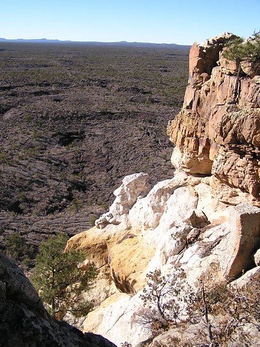
ESCALANTE, UTAH – State Route 12 in Utah is an awesome and very scenic road.

It twists. It turns. It curves. It climbs. It drops through the geological playground that dominates Garfield and Wayne counties on the Colorado Plateau in southern Utah.

The road offers new vistas guaranteed to take your breath away at every turn in Utah’s red-rock, high-country desert and beyond.

It runs past slickrock canyons, cliffs, Ponderosa pine and aspen forests, alpine lakes, national parks, state parks, a national monument, a national recreation area and small farming communities.

Route 12 is the main artery through one of the most rugged and isolated areas of the West. It was one of the last explored frontiers in the lower 48 states.

The route offers camping, hiking, trout fishing, mountain biking, hunting, cross-country skiing, horseback riding and riding all-terrain vehicles.

There are elk herds, strange geological formations, petrified forests and Anasazi Indians ruins/museum on the semicircular route, which ranges from 4,000 to 9,200 feet in elevation.

State Route 12 is a national Scenic Byway, one of 125 in the United States. It is also an All-American Highway, one of only 20 so designated by the Federal Highway Administration. … [read it all]

Chaco from Grants, New Mexico in a Day

Hi! I really enjoyed your sites. Could you comment on the relative insanity of driving from Grants (early), up the South route (Seven Lakes/ rt. 14) into Chaco (still open?), spending some time in Chaco, and leaving via the north road and staying at either the Post B&B or a little motel in Cuba. I’ll have an SUV. Thanks for any input and enjoy your travels. M.

M-

I’m assuming Seven Lakes Rd is the old original South Road (aka 57); I drove it about a month ago and it was OK though rugged.

I think you can get in from Grants and out in a day and enjoy seeing the ruins. Look on the map for a route from Grants via Milan (may be 53/506) — that’s the most direct way up from Grants and a nice route. When you hit BIA/Navajo 9, turn left/west for about 10 miles or so to hit the south road.

I don’t know anything useful about the Post B&B. As for Cuba, you’d think there’d be some motels or B&B’s there, but I can’t remember ever noticing any.

Assuming you’re returning to Abq, you could start your trip up 550/44 via Cuba and go beyond Chaco to Aztec — various hotels & B&B’s there. Then you could see Aztec Ruins and Salmon Ruins. From Aztec you could go to Chaco via the north road and *out* via the south and down to Grants for the next night.

Not that I mean to rewrite your plans for you. mjh

Canyon de Chelly, Arizona

The canyon of many spirits by Mary Kirk-Anderson

First occupied by humans thousands of years ago, Canyon de Chelly is one of the longest continuously inhabited landscapes in North America…

Canyon de Chelly’s sheer walls, spectacular rock monoliths and fascinating connection with the native communities who have called it home, create a sense of a living place with more than simple geography to recommend it.

De Chelly (pronounced de Shay, from a corruption of tsegi, or rock canyon, the Navajo name for the area) is in Arizona’s north- eastern corner, in the Four Corners region, and lies within the great lands of the Navajo Nation. In 1931 it became a National Monument site and it is unique among National Park Service units in that it remains home to the canyon community and the NPS works in partnership with the Navajo Nation to manage the park resources. It is essentially private land. With the exception of one walking trail, the only way to enter the canyon is with a Navajo guide.

Made up of several gorges, the canyon is one of the longest continuously inhabited landscapes in North America, first occupied by the ancestral puebloans about 2000 years ago. Today, the steep walls preserve in remarkable condition easily viewed ancient ruins and rock paintings from as far back as the 12th century, tracing occupation of the canyon by the ancient Anasazi people, the Hopi tribe and latterly the Navajo, who arrived in the 1700s. …

Canyon de Chelly is about 115km north of the I40 Interstate between Albuquerque, New Mexico, and Flagstaff, Arizona. …

Two excellent rim drives, north and south, offer a series of spectacular overlooks.

Canyon De Chelly National Monument (National Park Service)

Kuaua and Coronado State Monument, Bernalillo, New Mexico

ABQjournal: Coronado Today Kicks Off a Celebration of New Mexico Monuments’ 75th Anniversary By Kathleene Parker, For the Journal

Today, Kuaua and the state monument that protects it, Coronado, will launch the 75th anniversary of the founding of New Mexico’s monuments. Coronado State Monument shelters Pueblo and Spanish Colonial artifacts and is a vastly restored monument over what existed just months ago. …

Kuaua, a Tiwa word for evergreen, has long graced the spectacular landscape south of the Jemez River’s confluence with the Rio Grande near Bernalillo. The Sandia Mountains loom mightily a short distance to the southeast and the bosque along the Rio provides a montage of seasonal colors. Continue reading Kuaua and Coronado State Monument, Bernalillo, New Mexico

Ladron vs Valley of Fires

Q: Would it be an overdo to drive the Ladrone leg and end up at Bosque for sunset?

A: There are a couple of things to consider before driving around Ladron between I-40 and Magdalena. It’s dirt roads all the way. There are almost no signs. At most places where two dirt roads meet, it is *probably* obvious which way to go but people react differently in such situations. I drove for many miles thinking “am I on the right road?” At one point I had trouble with the truck and thought I would be stuck miles from nowhere.

The lack of signs was particularly a problem in finding Riley, which I passed several times, seeing it on a high point I couldn’t seem to reach.

Finally, one has to drive through the Rio Salado a few times on this route (only once, if one can’t find Riley). It may be completely dry right now. When I crossed, I was hesitant more because of sand than water.

If I were recommending a more cautious approach, I’d come up from Magdalena and turn back at the Rio Salado — that’s the prettiest stretch. Sadly, even here I had the complication of not being able to find the route directly out of Magdalena (but then, of course, I was unwilling to ask for directions), so I went too far west and wrapped around to the east to hit that route north of town. Ask at the Ranger Station on the main street (which is never open when I pass through).

All those things aside, I found it a wonderful drive. Still, it would be impressive to time it so well as to hit Bosque del Apache at the right time.

There is another option altogether (many others). Go towards Bosque del Apache. Get off at San Antonio, but don’t turn south to the Bosque (yet). Instead, keep heading east-southeast towards Carrizozo. Stop at the Valley of Fires lava flow — there are a couple of short hikes right there by the campground. One could go on to Carrizozo — I hear there is at least one great burger place there (plus two good ones in San Antonio). Although from Carrizozo one could look for ghost towns to the north (White Oak) — another long loop back to Albuquerque– or the Lincoln Nat’l Forest to the east or Three Rivers Petroglyphs to the south, these require longer days. Regardless, double back to San Antonio and then head south to Bosque for sunset (allowing a half hour or more for that last part before Bosque).

peace, mjh

Bosque del Apache National Wildlife Refuge

Bosque del Apache National Wildlife Refuge is south of San Antonio, south of Socorro, in central New Mexico, between I-25 and the Rio Grande. From late fall to early spring, thousands of geese, cranes and other migratory birds can be seen. There are spectacular mass fly-ins at sunset and fly-outs at sunrise, where thousands of birds arrive or depart in a short time.