
We started this day trip driving to the trailhead for the Chupadera Peak trail, a few miles north of the Bosque del Apache National Wildlife Refuge visitors center. Though we’ve known of this trail for awhile, we’ve never stopped, preferring to go on to view the birds in the bosque. This day, the trail was our destination. (Click this map thumbnail for larger image –>)
Turning off the main road south of San Antonio, the dirt road goes under a railroad trestle and ends at a line of small, struggling cottonwoods. The beginning of the trail can be a loop, with one leg to the left of the trailhead sign and the other to the right (this shorter leg is .5 miles). Both of these legs cross innumerable sandy washes that look just like nicely maintained trails — watch for cairns. The two legs meet by climbing either side of a low hill. At their juncture is a bench facing the bosque and the start of the “real” trail to Chupadera, another 4.3 miles west.
Though it was early March, it was also noon on a day of record heat (70’s). An occasional breeze made it bearable to the people, but the dog was walking on his tongue from the start. He stuck his head under the slatted bench for some respite. We only went a little farther. This might be a better mid-winter hike. Regardless, one needs to hit the trail well before noon. Eventually, the trail passes under I-25 and up to Chupadera. At over 9 miles of desert trail, I imagine few of Bosque’s many visitors have made the hike.
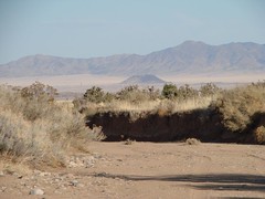
Still, that little bench on the hill has a panoramic view of the Rio Grande valley and the northern ponds of the refuge.
[more text and photos…]

We returned to the truck and cranked up the AC. Back in San Antonio, we stopped at the Fina for fudge, possibly the best anywhere. In a further shattering of tradition, we didn’t get burgers.
Maps show a road that might have spared us returning to Socorro for the next part of the trip, but that road isn’t accessible from northbound I-25, so we did return and take 60 west to Magdalena. If you haven’t been in the plains of San Augustin, go! It is a beautiful area with much to experience, including the San Mateo mountains, the Very Large Array, Datil (decent campground) and Pie Town (with the Sawtooth mountains in between). Ultimately, one can go on southwest to the Gila or loop back to I-40 via El Malpais.
We were ultimately northbound once we traveled far enough west. Again, maps promised roads that didn’t seem to pan out. Ranchers often gate roads that are actually public through-ways, if you aren’t afraid to get out among barking dogs.
Outside of Socorro, I caught a glimpse of a rugged canyon then a sign for “The Box.” Years ago, southwest of here, we stumbled upon the Monticello Box, which is a wonderful place we will visit many times. This Box — that rugged canyon — is far less wonderful, though cut through lava, which is interesting. Someone had pitched a tent at the end of the parking lot.
We went all the way to Magdalena (the subject of a Mothers of Invention song — well, not this town). Here the map plus GPS was quite useful in discovering the road north, which is far from obvious, just beyond the public library. Over the next 4+ hours, this road undulated through hills, arroyos and flat grasslands surrounded by lesser known mountains. It is the wide open high desert mesa country that I love so much, even at the height of juniper season. I discovered this route a couple of years ago, just a few weeks later in the year, when there were abundant wildflowers (albeit widely dispersed). No flowers this year, except for two clumps of verbena.
There are several roads that spur off the main route (354) towards the western Bear Mountains. I’m curious about the camping prospects, but still ignorant.
Some 30 miles north of Magdalena, one catches a glimpse of Riley on a hill ala Shangrila. Getting there takes you through a gate in front of somebody’s compound with a sharp turn to the Rio Salado, which you must drive across to Riley.
Understand, it’s the journey, not the destination, that matters in this trip, like many others. Not to disparage Riley, just to keep things in perspective. Riley is a ghost town with an apparently still lively church and just a few ramshackle building. I would call the location beautiful, knowing that many others would disagree.
After only minutes in Riley, we crossed the Salado again continuing north a short distance and crossed the Salado a third time. This last crossing may be 50 yards wide from low bank to bank, with barely a few yards of shallow, flowing water at this time. An easy ford, but the countless arroyos and washes attest to some turbulent water after a good storm.
We took a few fruitless sideroads looking for a route to Belen. A locked gate turned us back; a dead end did so another time. While I enjoy having GPS with topo software on my laptop, one must deal with the situation on the ground.
North from Riley, Ladron mountain is one’s marker. Keep Ladron’s sharp crags ahead and to the right of the road, aiming to pass around it, and, 20 miles later, you’ll hit I-25 at Bernardo, 47 miles south of Albuquerque. Obviously, one could start the loop there with lunch or dinner in Magdalena or Socorro (cross the old metal bridge and keep Ladron on the left of the road going west).
Ladron is rugged, little-visited and the subject of another daytrip.
In the final analysis, we spent 9 hours driving 250 miles to hike a few. We call this car-hiking. If one skips the extra distance to Bosque and wanders a little less, the loop might be done in 6 hours? I don’t know — we love to dawdle and gawk. mjh
 all photos
Nice story, Mark. I’ve been up Chupadera and also to Santa Rita (aka Riley) several times. When I had a house in Glenwood, I used to leave the pavement at Bernardo and take mostly dirt roads the whole way from there. That meant always going through Santa Rita (aka Riley).
I am a native New Mexican currently living in Ca. and cant wait to get home . My wife and I just purchased lot 14 at Santa Rita Ranches just north of Riley and hope to build a getaway there in the next few years
The road that lets you get to Rt. 60 from San Antonio is a little tricky to find, but worth the trip. (‘though you won’t save any time over the free way…) To find the road, head west out of San Antonio and head for the south bound freeway on-ramp. After you pass under the freeway there is a turn off on the left side of the road with a stop sign and a cattle guard. At the first ‘Y’ stay left, then just keep heading west. Sometimes this road is 2wd, but it goes through the bottom of a very narrow canyon so if there’s been any rain recently it can be pretty bad. (watch for the road-side shrine at the mouth of the box canyon.) The road lets out just past the Socorro box sign on 60.
I traveled the Bernardo Rt. to Santa Rita on Aug. 18th. It was the first time for me on that rd. The roadside shrine was quite interesting, and rather erie as I went past it at dusk. Also of interest was the Bus Stop out in the middle of no where
I traveled the Bernardo Rt. to Santa Rita on Aug. 18th. It was the first time for me on that rd. The roadside shrine was quite interesting, and rather erie as I went past it at dusk. Also of interest was the Bus Stop out in the middle of no where
I purchased lot 79 of the Santa Rita Ranches! I have spent some time there and already love it. Hikes toward Ladron are awesome adventures with cliffs, caves, and canyons!
Enjoyed the story of your trip through Riley. A friend and I visited the town in ’69 or ’70 in a dune buggy. Don’t remember exactly how we got there but on the way we passed through a 135 section ranch southwest of Belen manned by a lone cowboy who much enjoyed our short visit with him.