Category Archives: drought

Another dry year : jfleck at inkstain

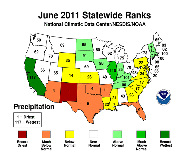
Science guy John Fleck lives not far from me, although far enough to have somewhat different precipitation. My unscientific method leaves me shocked that we’ve actually had more rain this year than last, but it’s still less than in one storm in other parts of the country. Yes, it’s dry.

Another dry year : jfleck at inkstain

Sept. 30 is the end of the “water year”*, and it’s been another dry one at the Heineman-Fleck house. With data back to the 1999-2000 year now, this is the fourth consecutive dry year relative to my personal long term mean here in Albuquerque’s near northeast heights:

Water year rainfall at the Heineman-Fleck house

Water year rainfall at the Heineman-Fleck house

Another dry year : jfleck at inkstain

You *must* see Drought’s Footprint – Graphic – NYTimes.com

Fascinating graphic of US drought patterns over a century. (Excellent example of data presentation.) Find your birth year and come forward — it’s never been worse for most of us. mjh

Drought’s Footprint – Graphic – NYTimes.com

Published: July 19, 2012

Drought’s Footprint

More than half of the country was under moderate to extreme drought in June, the largest area of the contiguous United States affected by such dryness in nearly 60 years. Nearly 1,300 counties across 29 states have been declared federal disaster areas. Areas under moderate to extreme drought in June of each year are shown in orange below.

Drought’s Footprint – Graphic – NYTimes.com

Fire Danger To Close Sandias Monday, 6/20/11

ABQJournal Online » Breaking: Fire Danger To Close Sandias

By Journal Staff on Fri, Jun 27, 2008

A large portion of the Sandia Mountains is expected to close Monday.

“We are in extreme fire danger that we’ve never seen before,”  said Sandia District Ranger Cid Morgan.
All picnic areas along the Sandia Crest Highway (N.M. 536) should remain open except for Nine Mile and Cienega Picnic Ground, but all back country hiking trails will be closed. The Foothill Trail will remain open.

Karen Takai, fire information officer for the Sandia Ranger District, said N.M. 165 will be closed from Placitas to the Balsam Glade Picnic Area except by special permit. Takai emphasized that the trail closures will including the popular La Luz Trail and the trail between the Sandia Peak Aerial Tramway and Sandia Peak. The tram and the peak will remain open.

ABQJournal Online » Breaking: Fire Danger To Close Sandias

ABQJournal Online » Maps of Area Forest Closures

OPEN areas include

• Sandia Crest Observation Area, Sandia Peak Tram and associated facilities, Sandia Peak Ski Area and associated facilities, and Sandia Crest House

• Recreation Day Use Sites: Cienega Canyon, Sulphur Canyon, Pine Flat, Doc Long (front of site only), Balsam Glade.

• Sandia Ranger District Administrative Site and the Tijeras Pueblo Interpretive Trail.

Open Trails: Those portions of Forest Trail 365, including secondary trails associated with Forest Trail 365, outside of the Sandia Mountain Wilderness, and South of the Tram.

Sandia Peak Ski Area mountain bike/hiking trails within the ski area

Open Roads:

• Forest Road 190 to Cienega Canyon Day Use Area.

• Forest Road 242

• Forest Road 413

The open areas are still under Stage II Fire Restrictions which include no smoking, fireworks, fires, stoves, grills, or open flame ; COLD PICKNICKING ONLY. No Dispersed Day Use and/or Camping is allowed along open Forest Service Roads or along State Highway 165.

ABQJournal Online » Maps of Area Forest Closures

Photos of Arizona’s Wallow Fire [note: New Mexico is burning, too, just smaller fires]

Aerial imagery of the Wallow Fire in Arizona | Google Earth Blog

Started on May 29, the Wallow Fire, located near the Arizona and New Mexico border, had already burned 389,000 acres when Landsat captured a stunning aerial image of it on June 7.

arizona.jpg

Smoke from the fire has affected air quality as far north as Wyoming and as far east as Georgia. The U.S. Geological Survey and NASA cooperate closely in managing the Landsat program and we have them to thank for images such as this.

To view it yourself in Google Earth, simply download this KML file.

Aerial imagery of the Wallow Fire in Arizona | Google Earth Blog

As usual, Boston’s The Big Picture has some great photos, although I hate scrolling to see them.

Arizona wildfire rages on – The Big Picture – Boston.com

2 Fire crew members sharpen their tools as they prepare for a back burn operation in Eagar, Arizona. A raging forest fire in eastern Arizona has scorched an area the size of Phoenix, threatening thousands of residents and emptying towns as the flames raced toward New Mexico, June 8, 2011. (Jae C. Hong/Associated Press) #

Arizona wildfire rages on – The Big Picture – Boston.com

June 2011 Arizona fires seen from space | Earth | EarthSky

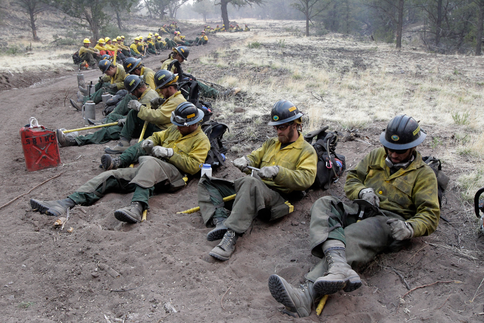
Three images taken from space of the Wallow North fire in Arizona in June 2011 show the fierce magnitude of this event.


June 2011 Arizona fires seen from space | Earth | EarthSky [via Arizona Hiking]

Arizona Wallow fire: Are wildfires getting worse? – By Jeremy Singer-Vine – Slate Magazine

Are large American wildfires becoming more common?

Yes, at least in the West, home to most of the nation’s largest wildfires.

Arizona Wallow fire: Are wildfires getting worse? – By Jeremy Singer-Vine – Slate Magazine [via dangerousmeta]

Hear! Hear! Stop the Water Hijackers

ABQJOURNAL OPINION/LETTERS: Talk of the Town

Hydro Thievery Is Just Morally Repugnant
        REGARDING THE Augustin water grabbers breaking their silence, what they have actually done is create a document of puffery and propaganda of which a peacock would be proud but no person of reason could take seriously.
        The plan to pump oceans of water from underneath the Plains of San Augustin would set a terrible precedent in which water would be sequestered and privatized for individual profit without regard to the wreckage of abandoned communities and environmental devastation left behind.
        Contrary to the corporate claim, it is not known how much water could be pumped from the Augustin basin without impairing the wells of people who live there and without affecting stream flows in the Gila and Alamosa rivers, both of which form rich wildlife corridors on which people depend.
        It is a ridiculous irony that the plan to pipe this water to the Rio Grande and make some as-yet-unsuspecting end users pay for it through the nose would likely undermine the stream flow from the Alamosa River that is already entering the Rio Grande basin for free right now.
MARY KATHERINE RAY
Winston

ABQJOURNAL OPINION/LETTERS: Talk of the Town

New Mexico Fire Information

ABQjournal: New Web Site to Help Get Word Out on Fires
The Associated Press

SANTA FE— New Mexicans will be able to use their computers for one-stop shopping to find out about wildfires around the state and what areas may be closed.

The new site, www.nmfireinfo.com, links all the fire sites in the state so anyone can connect to Web sites and get information about the entire region, said Kris Eriksen, interagency information coordinator.

“This centralizes information, making access to important wildland fire information and restrictions in the entire area easier and more logical,” she said.

The site will be updated continually, said Hans Stuart, a spokesman for the U.S. Bureau of Land Management.

What might prove most useful is information about “what’s open and what’s not,” Stuart said. “Most areas are open right now. … It’s a matter of restrictions on fires, partial closures here and there.”

Agencies involved in the site include the BLM, U.S. Forest Service, U.S. Fish and Wildlife Service, the U.S. Bureau of Indian Affairs, the National Park Service and the state of New Mexico.

The Southwest Regional Office of the Forest Service also offers a toll-free telephone number for restrictions and closures: (877) 864-6985.